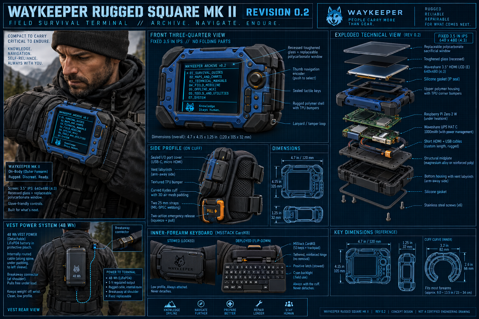
WayKeeper™ RUGGED concept artwork. This illustrates the proposed build; it is not a photograph of tested hardware.
An open-source ANSI terminal brings offline maps, manuals and repair references into a DIY field computer—and takes an unusually restrained approach to AI.
A campsite does not need to become a disaster zone for an offline computer to become useful. A valley without reception, a downloaded manual buried among hundreds of files, or a forgotten equipment setting can be enough. The immediate question is practical: can you find the information you brought?
WayKeeper™ approaches that question with the visual vocabulary of a terminal: compact text, fixed workspaces and maps rendered in ANSI. Behind the saluting mascot is an ambitious DIY project aimed at camping, field repair and preparedness. Its appeal extends from an ordinary weekend away to the much harder problem of keeping a usable reference library when connectivity is unavailable for days.
The project is open to inspection in the WayKeeper GitHub repository. What follows is a look at its source, build plans and documented development results—not a wilderness endurance test.
A useful job before the emergency
Consider the trip preparation: select regional maps, load the relevant equipment manuals, make a camp inventory, and check that everything opens with networking disabled. At camp, the same device can hold notes, retrieve a source page or help a technically qualified owner find the documentation for a repair. A serial I/O workspace adds a route into deliberately connected equipment; it does not magically make an unknown connector safe to use.
The longer-term use case is continuity. During an extended outage, a household or small workshop could keep local records alongside references on food preservation, agriculture, electronics and maintenance. The value is being able to reopen a particular document tomorrow, with its source and limitations still attached. WayKeeper's documented workspaces include cards, a library, journals, maps, inventory and field I/O.
That makes it a plausible companion to existing outdoor equipment. It still needs a deliberate place in the kit: power, protected storage, familiar controls and knowledge of what has actually been installed.
Offline ANSI maps are the headline
The most distinctive feature is the map screen. WayKeeper's documented national collection covers all 50 U.S. states, using 61 terrain tiles, with roads, towns, rail, trails and inland-water layers where the underlying datasets provide them. F6 discovers installed state packs; the maps can be consulted without fetching a live web tile. Map documentation
ANSI gives terrain and geographic relationships a compact presentation inside the same terminal used for the rest of the device. A camper can inspect the relationship between a valley, a road and nearby settlements, then return to a journal or manual without switching into a network-dependent service. The reduced detail invites a more deliberate kind of reading.
There are boundaries to that claim. National coverage does not mean every trail is present or every crossing is current. The project describes these as field-orientation maps, not street atlases or proof of access. A mapped water feature is not a water-quality report. Its Full and Lite packs also differ: Lite reduces road detail and omits rail and trails.
The default workflow uses manual coordinates, with live GPS treated as optional hardware. That choice should not be confused with a limitation of GPS itself: satellite positioning can work without cellular service or internet. WayKeeper asks the operator to retain map-reading skills; it does not supply an automatic position fix merely because a map is visible. Project navigation notes
The AI decision is surprisingly modest
“Offline AI” can describe very different products. Some run a language model on a phone or dedicated computer. Others store documents locally but depend on a remote service to generate an answer.
WayKeeper includes a local LLM adapter, yet inference is disabled in its small-board embedded profiles. The Pi Zero 2 W and Orange Pi Zero 2 direction prioritizes memory and power for reference retrieval and the terminal. A more capable, powered AI configuration remains a future development path. Architecture and release notes
That is an important distinction when comparing it with a device sold around conversational intelligence. WayKeeper's current baseline is built to find and display material. It does not promise to reason through an unfamiliar emergency on behalf of its owner.
What does a $1,000 alternative buy?
The fairest comparison separates software, assembled computers and navigation equipment. These prices are not equivalent shopping baskets.
| Approach | Price context | Practical distinction |
|---|---|---|
| WayKeeper DIY Rev 0.2 | The build plan estimates US$350–$500 for a typical prototype; this is a planning figure, not a retail offer. | Source access, a compact ANSI interface and a customizable local library. Assembly, validation and maintenance belong to the builder. DIY specification |
| Vanguard Workstation | Its vendor advertises a US$999 founder preorder, against a stated US$1,499 standard price. | Advertised as an assembled offline-AI workstation with a 10.1-inch display, 8 GB RAM and 1 TB storage. Those specifications target local model use and a larger workspace. Availability and performance were not independently tested for this article. Vendor listing |
| SURVIA on a compatible phone | Its site advertises free beta access and CAD$59 at launch; confirm current availability. The phone is separate. | The developer describes on-device AI and offline maps. Reusing a compatible phone can avoid a dedicated hardware purchase, but remains a different interface and software stack. Developer site |
| Garmin Montana 710/710i/760i | Garmin announced US$649.99–$899.99 launch MSRPs in January 2025; these are historical prices, not current quotes. | Dedicated GNSS navigation and preloaded maps; the 710i/760i add inReach communication with an active subscription. This is a navigation and communications comparison, not an AI benchmark. Garmin announcement |
WayKeeper's lower proposed build cost comes with real work attached. An assembled product may buy convenience, integration and support. A navigation handset addresses positioning and, on suitable models and plans, messaging capabilities that WayKeeper's baseline does not provide. Conversely, a conversational AI feature is not necessary to open a map or locate a known manual passage.
The useful buying question is which task needs to keep working, on what power supply, and with how much operator involvement. This feature makes no claim that WayKeeper outperforms those products in inference, navigation, durability or battery endurance.
A library is only as good as its readable pages
The project's latest local processing report records 224 distinct PDFs converted into 35,580 ANSI source-page references, occupying about 98 MiB of text. Native SQLite full-text search makes the reference collection searchable from the terminal. These are transcribed source pages—not 35,580 independently checked survival instructions. Processing report
The same report leaves 2,383 low-text pages awaiting visual or OCR screening and excludes two unreliable table extractions. A separate collection contains 55 instruction candidates awaiting review. That distinction matters more than the headline page count: text extraction can lose a diagram, a unit or the relationship between table columns. Search makes material easier to find; it does not certify the material.
Hardware claims deserve the same care. Rev 0.2 favors a fixed 3.5-inch display over the earlier flexible AMOLED/FOLED concept. Ruggedness is a design direction, and the specification explicitly describes prototype equipment rather than certified protection. One-to-two-day operation is a conditional low-duty target, not a demonstrated continuous-use battery rating. The power and thermal plan is the place to examine the assumptions.
Start with the weekend trip
WayKeeper's strongest introduction may be a modest one: prepare it for the next camp, learn its map key, find a manual with the network off, and discover which parts of the workflow deserve improvement. Familiarity gained on an ordinary afternoon is more useful than first encountering an interface during an outage.
Builders can explore the MIT-licensed code and project documentation, read the DIY plans, and bring fixes through HACKING.md. For the accompanying build instructions, open the RUGGED field manual or the FOLED field manual on INIT.WTF.
Flashable board images and the .iso release bundle are still forthcoming, according to the repository's release notes. Today, the invitation is to inspect, build and improve a field computer whose maps and library are meant to remain available when the network does not.